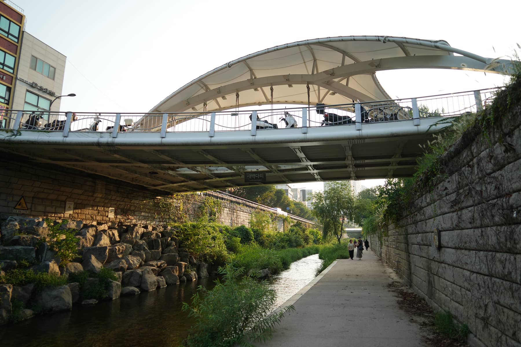


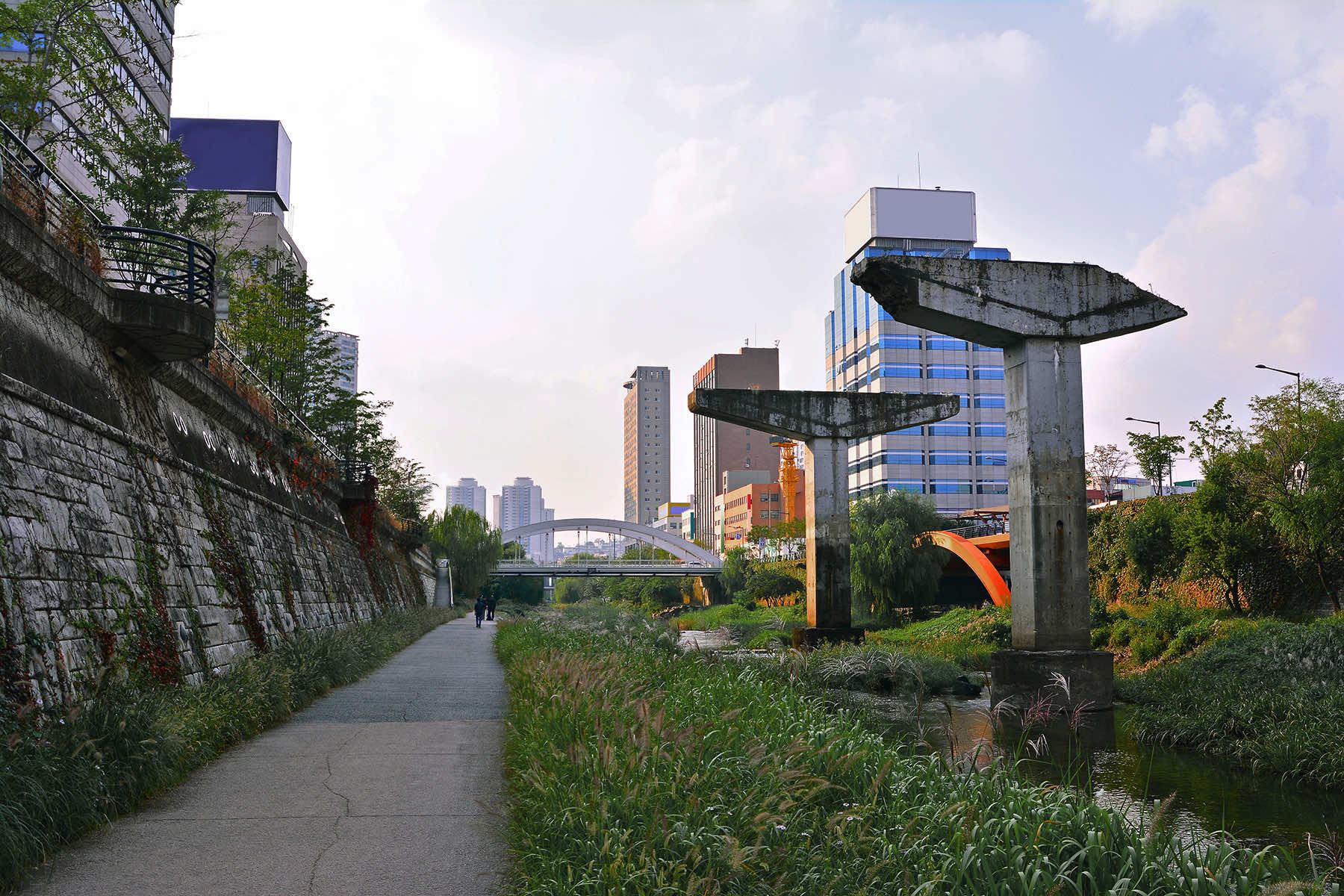
Across the heart of Seoul, a river runs in a space previously buried under a concrete freeway. Once hailed as a monument to South Korea’s rapid modernization, the elevated Jonchigyogak ultimately became known as a “car sewer.”
The elevated Cheonggye Expressway Overpass that ran above the Cheonggyecheon Stream was a decaying corridor of concrete that choked off the city’s downtown, polluted the air, and drove residents and businesses away.
What had been a symbol of rapid modernization in the 1960s ultimately came to be seen as an urban planning catastrophe for life in the downtown core. By the 1990s, traffic around the expressway had grown intolerable, air and noise pollution levels soared, and downtown businesses were shuttering at an alarming rate. Half the downtown population had disappeared.
The Cheonggye Expressway was crumbling, physically and metaphorically. Instead of rebuilding, the city made the radical decision to remove the freeway and restore the stream beneath it.
What followed was one of the most ambitious and successful urban transformation projects in the world. In its place now flows a 6-kilometer linear park, teeming with walkers, wildlife, cultural spaces, and shaded seating. It is a vivid reversal of decades of car-first planning.
As Milwaukee approaches a critical decision about the future of Interstate 794, the lessons from Seoul offer both an inspiration and a data-backed model for how freeway removal can restore urban vitality.
A FREEWAY THAT NEVER FIT
The story of I-794 begins, like Seoul’s elevated expressway, with 20th-century visions of car-centric progress. Built in the late 1960s and early ’70s, the East-West Freeway extension and Hoan Bridge were imagined as key pieces of a grand “Downtown Loop.”
But as community resistance surged, backed by the newly enacted National Environmental Policy Act, the full loop was never completed. Left disconnected for years, the Hoan Bridge became known locally as “the bridge to nowhere.”
Today, I-794 serves as a relic of this failed vision. Though designed to move over 100,000 vehicles per day, it never reached that capacity. The Wisconsin Department of Transportation’s most recent figures show a fraction of that usage, between 38,000 and 68,000 vehicles, depending on the segment.
Its oversized ramps, redundant interchanges, and confusing layout now serve primarily suburban commuters, not the growing population of the Third Ward or the downtown residents who have driven Milwaukee’s modest urban revival.
More telling is what sits beneath the freeway, which is nearly 33 acres of publicly owned land, much of it underutilized or lost to surface parking. Based on nearby development metrics, this land could be worth over $1.5 billion if reimagined.
Instead of acting as a conduit between the lakefront and the city center, I-794 divides them. For pedestrians and cyclists, the structure is an obstacle. For neighborhoods like the Historic Third Ward, it remains a psychological and physical barrier that cuts them off from the Milwaukee River, Lake Michigan, and each other.
A STREAM RESTORED, A CITY REUNITED
Seoul’s decision to remove the Cheonggye Expressway faced familiar criticisms. There were forecasts of traffic gridlock, business disruption, and sky-high costs. Yet none of these predictions came to pass.
Within three years of the expressway’s demolition, motor vehicle traffic had fallen 45%. Bus ridership rose 15%, metro usage increased by 3%, and most critically, travel times for drivers did not increase.
But the traffic data was only the beginning. Nitrogen dioxide levels fell 35%. Average summer temperatures near the restored stream dropped by more than three degrees. Bird and fish populations returned.
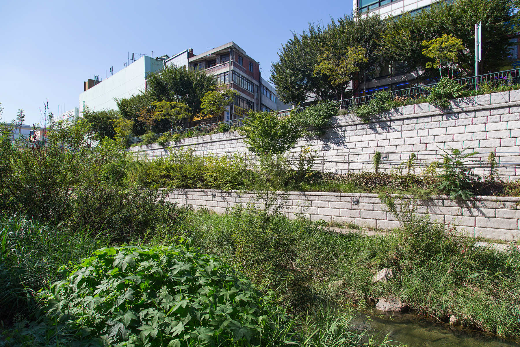
Small businesses soon re-emerged. The once-bleak corridor transformed into one of Seoul’s most visited public spaces. It is a park that blends water management infrastructure with public art, shaded seating, historic markers, and cultural programming.
Importantly, the project did not just remove a blight, it created a destination. What had once been a scar across the city became a place of gathering and identity. So successful was the transformation that Seoul continued removing more elevated highways, each time replacing asphalt with space for people.
THE PARALLEL FOR MILWAUKEE
Milwaukee has already seen a version of this success. When the Park East Freeway was removed in the early 2000s, it unlocked 24 acres of downtown land. Over $1 billion in private investment followed, including the development of the Deer District and the Fiserv Forum.
Critics had also predicted traffic congestion, but studies have since found no such impact. Traffic organically navigated through the existing road network, helped in part by an increase in public transit ridership.
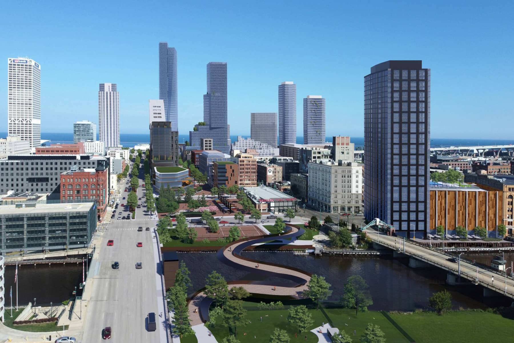
So why is Wisconsin preparing to spend $300 million to reconstruct the eastern stretch of I-794, a corridor its own consultants have described as oversized for its current and projected traffic?
The proposed rebuild would entrench the same flaws that have long hampered the corridor: severed neighborhoods, dead space, noise, pollution, and inefficient land use. Instead, the “Rethink 794” campaign proposes a bold alternative: remove the elevated structure between the Milwaukee River and the Hoan Bridge.
In its place, Clybourn Street could be reborn as a multi-modal boulevard, a human-scaled corridor supporting small businesses, housing, and green space. With narrower lanes, slower traffic, and pedestrian priority, the boulevard could finally reconnect the Historic Third Ward to downtown and the lakefront.
Unlike the expressway above it, a surface-level Clybourn corridor could become a place where people stop rather than speed through. Current proposals envision widened sidewalks, bike lanes, new housing, retail storefronts, and even car-free pedestrian plazas.
One concept would transform a 70-foot-wide swath of land into a linear gathering space, open only to people, linking the Milwaukee River to Lake Michigan. With shaded seating, tree-lined walkways, and year-round accessibility, this proposal directly echoes what Seoul achieved with Cheonggyecheon by reimagining infrastructure as a tool for public life, not merely private transit.
PROOF OF CONCEPT ALREADY IN MILWAUKEE
This vision is grounded in precedent. The Third Ward, once hollowed out by White flight and freeway construction, has seen its population swell from a reported 36 residents in 1985 to nearly 25,000 today. It is now one of Milwaukee’s most successful mixed-use neighborhoods, precisely because it centers walkability, density, and neighborhood identity.
The vibrancy of the RiverWalk, the success of the Deer District, and the Lakefront Gateway’s improvements to pedestrian access all show that human-scale projects work. Meanwhile, I-794 continues to dampen property values, generate disconnection, and eat up space that could fuel Milwaukee’s continued resurgence.
The economic case is undeniable. Replacing I-794 with a boulevard would unlock over $30 million in annual tax revenue, much of it driven by new development. And as was the case in Seoul, Milwaukee could expect to see improvements in air quality, reductions in traffic noise, and increased use of alternative transportation.
Seoul’s transformation also demonstrated how these projects can draw visitors and revitalize tourism. Cheonggyecheon is now among the most photographed locations in the city.
Opponents of removal often point to commuting concerns. But the Park East project, and similar removals in cities like San Francisco, Portland, and New York, have shown that traffic does not collapse when elevated highways are removed. It redistributes.
More people opt to walk, bike, or take transit. And just as importantly, fewer people choose to drive when car infrastructure no longer dominates the landscape. This phenomenon, called “traffic evaporation,” is not just theory. It was measured directly in Seoul. After the expressway’s demolition, ridership on buses and subways increased, and car traffic simply declined.
Critically, Milwaukee’s underutilized street grid is already capable of absorbing the current I-794 traffic load. A network of streets that are currently fragmented, dominated by surface parking, or intentionally deprioritized in favor of freeway ramps, could be reconnected. That means easier navigation, more access for local businesses, and a more walkable, safer downtown for everyone, including drivers.
DESIGNING FOR THE FUTURE, NOT PRESERVING THE PAST
Milwaukee is not the first city to face this choice. But it may be one of the few with both the precedent and public support needed to do something bold. Mayor Cavalier Johnson has signaled openness to alternatives, and the Wisconsin Department of Transportation has already committed to studying other options for the Stadium Freeway.
With I-794 approaching the end of its engineered lifespan, the timing is urgent. The city can either lock in another 50 years of division and disrepair, or pursue a future where public space, economic development, and environmental responsibility align.
Seoul did not just replace a highway, it healed a scar. Milwaukee now faces its own opportunity to correct a historic planning mistake, not by returning to some imagined past, but by designing for the future.
“Rethinking I-794” is not about nostalgia, it is about facing facts. The freeway is underused, overbuilt, and economically unsustainable. Its removal is not a gamble, it is an economic strategy backed by proven outcomes.
If Seoul can turn a car sewer into a civic gem, there is no reason Milwaukee cannot do the same. A thriving and connected downtown is not a dream. It is a purposeful decision.

Noria Doyle and Lee Matz
Lee Matz, with KHan3145, Cherry-Hai, Jacksonville Rising (via Shutterstock)